Saturday, March 27, 2010

Chasing the moon

Sorry for the enormous gap between posts. We did not sink or even forget how to type. The problem was merely a technical one. The backlight on our computer quit. We were not able to get a new one until we got to St Martin (technically Sint Maarten, the Dutch side where the prices are essentially like those in North America). We now have a Lenovo notebook computer that is about one quarter the size of our laptop but seems to do the job nicely. After the purchase we fired up the old machine to see if we could get some data off - using the tv for a screen and the stupid thing worked! There still is a problem with the keyboard that we cannot resolve until we are back in the US but we might end up with two computers.

We are now in Puerto Rico which means that there is a lot of ground (and more water) to cover. Rather than try to write a comprehensive take on the last few months - just some highlights and a few interesting pics ... and not the normal beach pictures. North of St Vincent there is an interesting alternation of former British colonies and current parts of France. The French have decided that their former colonies should become just parts of the nation. The result is that they are also part of the EU and $much$ richer than their neighbours.


St Lucia -- This is a lovely island and illustrates well the shifting colonial history of the entire region. Islands were won and last in battle and often returned by treaties or were bough and sold so that virtually every large island has had two or more owners: French, English, Spanish, Dutch, and even Danish. Most of the place names in English islands like St Lucia are French since the French were in control for many decades or even longer when places were being named. Few of these names were changed.

Picture is of the market in Castries in St Lucia (contrary to the T-shirt). These markets are always fun to visit and this one was particularly large and active.


Martinique - Martinique is a lovely island that is only a few hours sail from St Lucia. We spent several days in Ste Anne at a comfortable anchorage just off a long beach and very nice, small town with great baguettes (a major consideration when at any French island.) Ste. Anne is adjacent to a larger town called Marin that is a major sailing centre by any definition - for example, there are something like a dozen boat brokerages there.

After Ste Anne we stopped in the former capital, St Pierre. St Pierre's main claim to fame is that it was destroyed by its volcano in 1902 with 30,000 deaths and one survivor. They have kept a few of the ruins, for example a major theatre and some stores and there is a small, yet interesting, museum. The heat of the eruption can be seen in a large bronze church bell that softened and reshaped itself.

Here is June hard at work in St. Pierre. The town is in the foreground with the volcano behind. Hard to imagine such devastation from such a beautiful mountain.


This is the ruin of the city jail in St Pierre - which was right next door to the town's pride and joy, the opera house. The only survivor of the volcano was a prisoner housed in the tiny building in the lower right corner of the picture. Afterward he joined P.T. Barnum's travelling show of oddities where he showed off his burn scars.


Dominica - Dominica is a particularly lush island that has not been able to take advantage of tourism because there is not enough level land on the island to allow for a full-sized airport. Hence it is a bit poorer than many of its neighbours - and much poorer than its immediate French neighbours.

The guidebooks say that you should only anchor in the northern part of the large bay off Portsmouth because there have been significant numbers of thefts from boats at night. In fact, a local association of tourist companies, taxi owners and the like provide a marine patrol at night in this area. When we did an island tour the taxi driver said there wasn't a particular problem because the two brothers who steal from boats were currently in jail. Seems like the last time they got out a jail a theft occurred almost instantly from a boat. The police started their 'inquiries' at the brothers' house and found the stolen goods. Hence the boys are back in jail for a couple more years - they really should post their current residence in the cruising guides and then people would know where they can anchor. A more serious comment... the cruising community is hyper-conscious of security issues; to my mind more so than is justified. The result is that bad publicity about a place means that no boats will stop which can have a devastating impact on the economy. This happened to one formerly popular bay in St Vincent and the folks in Dominica saw that was it happening there and made moves to insure that visiting boaters felt comfortable and secure.

The picture below is of a neat restaurant up in the mountains that we visited while on a tour of Dominica. It had a fabulous view over the ocean and excellent local food - eaten out of a calabash which is a dried gourd.


Guadeloupe - This is one of my favourites down here. Guadeloupe is shaped like a beautiful butterfly with a mountainous half and a flatter half. It is all very modern with tall buildings and excellent highways - we shared a car rental with a nice young Swiss couple and did a tour to the mountainous part of the island, called Basse Terre - go figure. While there we climbed to the top of the smouldering volcano, La Soufriere which was almost 1500 m high. It was a fascinating experience as we climbed up above the clouds that are almost always there to temperatures around 15C and winds almost strong enough to blow one off their feet. In places you could see gases coming out of the mountain and there are hot springs. The last eruption was in 1972 and it is closely monitored since a major eruption could happen at any time.

Top photo is of the intrepid mountaineers at the top of the mountain. Lower pic is looking into the crater of the volcano.. Just visible is a probe that is used to sample the gases coming out of the volcano. In this photo it is very hard to determine what is cloud and what is gas from the earth.


While we in Guadeloupe we also went to one of the Carnival parades. People in Guadeloupe take their partying very seriously and their religion somewhat less so. Mardi Gras (Fat Tuesday) is the final day of partying in Rio, New Orleans and everywhere else that has a Carnival. In Guadeloupe they have decided to have an additional day of Carnival on Ash Wednesday. I guess this is OK because the focus of the day is to banish the devil, but the festivities are the same as the previous day. Finally, because Lent is very long they have decided to add a day of Carnival in the middle of Lent because ... well, I guess because one cannot go that long without a proper (or improper) party.

Waiting for the parade. Many of children were dressed up in very fancy clothes for the event.


Each group in the parade tried to outdo its rivals by having the most fabulous costumes and best (and loudest) music. these groups ranged from 15 or so to at least 100 so it is easy to imagine how much time and money went into creating these displays. There was even a group of Breton ancestry with bagpipes who were doing dances that looked very much like Scottish country dancing - the Celts did get around.


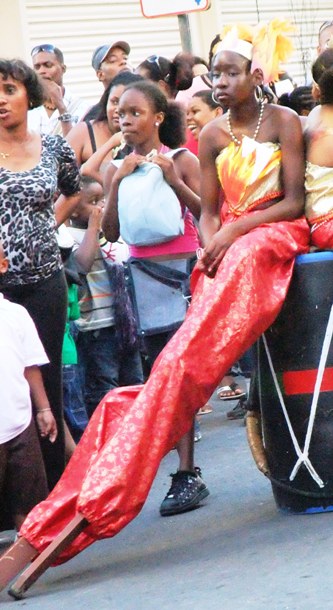
During a delay in the parade this girl had a chance for a break from walking on her stilts for at least a couple of hours. When she was on the stilts she was full of energy and charm but during the rest you could see that it was a very tiring thing to do.


There is a narrow divide between the two halves of Guadeloupe called the Riviere Salee. Boats that are not too deep can take this to get from the south shore to the north shore - and the reverse of course. The only problem is that they only open the three bridges over the Riviere once a day. For us the first bridge opening was at 5 am with the second about 20 minutes later. Of course, it was pitch dark and three of the lighted buoys on the route were, well, not lighted. I had warned myself not to first in-line of the five or so boats going through but did not manage to do this. Dumb! Anyway, we got through and it was interesting trip into a large area of mangrove swamps and huge numbers of birds.

Back to our focus on volcanism, an early feature of our visit to Guadeloupe (actually the southern islands of 'The Saints') was the depostion of a considerable amount of volcanic ash on our deck and even inside the boat. I woke up early one morning to pee and had the distinct feeling that we had a lot of sand on the floor. An hour or so later I turned on Chris Parker's weather report on the SSB radio and he announced that a third of the lava dome on Montserrat had exploded during the previous evening. The ash reached something like 30,000 feet and was carried eastward by the jet stream. The ash fall continued for 36 hours and schools and the airport in Guadeloupe were closed for two days. For us it meant a couple of hours of careful cleaning both inside and out on Ainia. The material was interesting in the sense that it was very fine but did not form mud when wet - sort of like very fine sand. This photo shows some of the boat before the cleanup.


Antigua - The alternation of British and French islands continued with Antigua. This island has the rare distinction of never changing hands. It was only ever British. A major reason for this was the famous, and impregnable, bay called English Harbour. With the help of two or three forts at the mouth this was a perfect base for th4 Royal Navy. A bonus was that English Harbour was a superb hurricane hole as well. They have done a terrific job of restoring buildings at Nelson's Dockyard as it was named after Trafalgar. In fact Horatio was stationed there for three years as a fairly junior captain, long before he became a heroic and iconic figure of British history.

Antigua was also the first, along with St Martin, of the two famous mega-yacht bases. Two quick stories about that. Antigua is the home for two J-boats, the type that raced for the America's Cup in the 1930s. Velsheda was owned by the man who owned the Woolworth chain and is the original boat. Ranger is actually a replica of original and is for sale now for only $20 million (see http://www.jclassyachts.com/ranger/RANGER%20specs%20&%20pp.pdf). BTW, the original Ranger was owned by someone named Vanderbilt. We saw Velsheda come into an anchorage on the east side of Antigua and just sit there for about half an hour - we could not figure out why. Then her 'tender' came in - a powerboat about 145' long. She anchored and then the J-boat rafter to it for the night. I guess there was not enough accomodation on the sailboat to the owners or, more likely, charterers.

This picture (not ours) is of Ranger competing in the Antigua Classic Yacht Regatta. In 2009, Ranger and Velsheda had a 'little' collision (there are no 'little' collisions of boats like these) in this regatta. I don't even want to think about how much the repairs were. Interestingly, Ainia would qualify for the second oldest group in this regatta (0ver 25 years).


Antigua is also the winter home for Mirabella V, the largest single-masted boat ever built (247' LOA). Mirabella V is available for charter (reportedly for $350,000 week) and also for sale if you need to move up from your current vessel. More at http://www.mirabellayachts.com/. The boats tied up either side of Mirabella were probably in the 150' range but looked quite tiny.

St Martin/Sint Maarten -This is a most unusual island. It is partly French (St Martin) and partly Dutch (Sint Maarten) and mostly American. The US dollar is the main currency (many places take the Euro and dollar at par so you see few Euros) and everyone speaks English - on the Dutch side almost as a first language. The French side is quite nice and the Dutch side is quite is useful. The latter is duty-free so a lot of stuff is very cheap there. The result is that almost all the serious shopping is here. We bought a new windlass for the anchor at less than US prices and the new computer at US-competitive prices. Prices are often quoted in three currencies - US dollars, Euros and Dutch Antilles Guilders (usually called Florins). Apparently when the Dutch switched to Euro they neglected to tell their colonies so the Florin lives on.

There is no real border between the two other than a line on the map. Most boats anchor on the French side because it is free and take their dinghies to the boat stores, marine services and supermarkets on the Dutch side. The Dutch built a new bridge to the interior lagoon and want to pay for it, so there is a bridge charge, an anchoring charge and a clearance charge. The French charge 5 Euros to clear in and their bridge and anchoring are free.

While there we went to Orient Beach which is reputed to be the best beach in the Caribbean. It is a beautiful beach but very commercialized with five companies having the right to rent their hundreds of beach chairs and umbrellas with only a few areas open for free use. The less said about the bodies to be found on the nude part of the beach the better.

BVIs - It is an overnight sail from St Martin to Virgins. I talked in earlier posting about the BVIs so will skip it here except to say that it was even busier with charter yachts than before.

Puerto Rico - From the BVIs we went directly to Culebra in Puerto Rico (PR), skipping over the US Virgins. We have spent time in four places in PR and it seems like a very nice place. We were going to rent a car to go sightseeing but we had forgotten that it is Easter weekend and cars seem no available at all. We need to some serious shopping here before heading on to the Bahamas where we understand everything is enormously expensive. We also need to send off June's US income tax returns (federal and state). After they are done we can work on the Canadian returns.
This is the rather wonderful library in Culebra, PR. The trailer on the left seems to be for storage while the one on the right is the actual library. It has a children's room, a computer/internet room and an adult book room. It is entirely run by volunteers and is open for four hours a day on four days of the week. You don't even have to be a local resident to take books out.


This dolphin came to play with us as we were sailing along the south coast of Puerto Rico. He kept circling back to us as if to encourage us to go faster. At times he seemed to be almost touching the boat. After about 10 minutes he gave up and left.


+++++++

Three Passages
One of really neat things about extended cruising is the enormous variety of sailing experiences. Three of these follow.
1. Antigua to St Martin - This is too far for a daylight trip so the question was what time should we leave Jolly Harbour in Antigua to get to St Martin in the morning so we could clear Customs and get settled. We used a projected speed of 5 knots because it was supposed to be very windy and we don't like to motor if we can avoid it. This meant a departure around lunchtime. During the afternoon this looked optimistic as were doing more like 3.5 to 4 knots. As darkness approached I wondered if we might end up using the iron genoa (the engine to non-sailors) since the wind often drops at night ... except it did not. We started to go pretty fast - more than 7 knots so the problem became one of slowing down. We reefed the main and then reefed the main some more and then reefed the jib and then totally rolled up the main but we could not get our speed below 6 knots. The result was an arrival at the exposed and windy harbour of Marigot at 4 am and having to anchor in the pitch dark in the outer harbour among the mega-yachts.


2. St Martin to Virgin Gorda - This was the passage that inspired the title of this post - chasing the moon. Again we postulated a speed to arrive in the Virgins in the early morning ... and everything worked exactly according to plan. We averaged around 5.5 knots and for most of the night were aiming right at the reflection of the almost full moon. We arrived when we expected after a very relaxed trip.


3. Vieques to Salinas, PR - We knew this was going to be a run and the previous day we had had no great success running with just the jib up. It frequently collapsed and then popped open with a loud noise and wear and tear on the boat. We decided to use the asymmetric spinnaker and see how it would do. We did 50+ miles and averaged between 4.5 and 8 knots as the wind strengthened during the day. A bonus was that the sail was perfectly behaved and the boat totally stable and comfortable. It is a big sail to get up and down (1300+ sq ft) but worth it if it is going to be up for a long time.


+++++

Next ... we will be in PR for a few more days and have decided to make a big push to get to the southern Bahamas (weather permitting). We are going directly to Great Inagua Island from PR which is about 400 miles and should take about 3 days or so.

Thursday, January 28, 2010

Heading north

This is a very fine example of a nutmeg tree. It is about 10 m high and had hundreds of nutmegs growing on it. Almost all of these trees in Grenada were killed by the hurricane. This is in St Vincent near Wallialabou.


Here is the hapless vessel 'Roundabout' aground on the Roundabout Reef in Clifton, Union Island. The dozen or so boats eventually got it off after about half an hour/

Cacao plant in Grenada. All of the various kinds of plants grow in what appears to be a jungle but has been carefully planted.


This cruiser was also a magician. After the tutoring she gave an impromptu performance. You could not have asked for a more rapt audience.


This is part of the Rivers rum factory. The crushed sugar cane is put into these open stone basins to partly evaporate. At this stage it looks like nasty sludge.


We are now in Rodney Bay, St Lucia so we are two degrees of latitude (120 nautical miles) north of our furthest south position on the south coast of Grenada. St Lucia was one of the islands we skipped on the way south by doing an overnight passage from Guadeloupe to St Vincent on the way down.

We have had terrific sailing up from Grenada. We went on the windward side of Grenada on the way to Carriacou (most people go on the leeward (western) side since it gives one a better angle to the wind, but we had to deal with strong and shifting currents. At one point the boat’s heading as shown by the compass was about 30 degrees different than our course over the bottom as shown by the GPS. We also noticed that there is a line of unmarked rocks extending out from a marked rock on the chart – by something over 100 m.

Carriacou is part of Grenada even though it is only about two miles from Union Island, which is part of St Vincent and the Grenadines – so you have to clear out of one country and then clear into the other country, a bit of an inconvenience to say the least. From Union Island we had a tremendous sail to Bequia where we stayed for a few days. We left there a day or so before our original plans because there were good winds forecast for a couple of days (more easterly than northeasterly). We skipped going to Kingstown, the capital of St Vincent and stopped instead in Wallilabou on the west coast. This pretty spot’s main claim to fame is that the three Pirates of the Caribbean movies were partly filmed here. The remains of the some of the permanent sets are there and there are tours from cruise ships and the like to see them (not really worth it). The remarkable thing is how small the set is for the town in the movies – only a few store fronts that they must shoot from different angles and with different barrels, cannons and bales in front to make it look like a different place.

The harbour in Wallilabou (they do have great names here!) is very deep and you need to drop an anchor quite close to shore (still in 50`+ of water) and have a `line handler` take a stern line ashore to tie to a tree root or whatever. From there we had another terrific sail of 58 miles to Rodney Bay and arrived in time (330 pm) to clear customs here. We will stay here for a week or so to do some boat repair/upgrade stuff and major shopping.

It is remarkable how different each of these bigger islands is from its neighbours even though the basic geology and weather factors are the same. St Vincent and Dominica are lush, even on the leeward slope. The mountains in St Vincent seem `sharper` than the neighbours even though St Lucia is famous for the two Pitons (mountains) in the south. St Lucia seems much richer with modern supermarkets and a huge marina set up to handle even very big yachts (100`+).

From here we will be going to Martinique and are already trying to figure out how many bottles of wine we can store onboard. Before I close for now, so comments on other highlights of the past few weeks.

Grenada – Tour and Tutoring
We went on all-day tour of the island with about 10 people in one of the large taxis that are ubiquitous everywhere you go outside the rich countries (including Jordan and southern Africa). Different tour guides have different specialities and Cutty’s was the island’s plants. On Grenada this was fascinating because the island’s nickname is the Spice Island. We got to see how nutmeg, cinnamon, cacao, and about a dozen other crops grow. Until the big hurricane in 2004 Grenada was the second largest source of nutmeg in the world. The hurricane killed so many nutmeg trees that production fell by 90%. (Grenada is still #3 in the world so nutmeg is not widely grown.) The new trees will start to produce in the next couple of years so nutmeg prices may drop I guess. We also visited the (only) nutmeg processing plant. Much of the work is done by hand. This large wooden building filled with sacks of dried and drying nutmeg is just a catastrophic fire waiting to happen.

On the tour we also visited a quite remarkable rum processing plant. The most high-tech things in the plant are a few plastic pipes and valves of the sort that you could pick up at a Home Depot. Other than that the whole thing looked like it could have come directly from 1850. It is powered by a very large iron waterwheel that was made in England in 1780 and has been at the mill since then. Other than that, it is only gravity that is used to move the liquid through the production process. They only make over-proof rum and if the stuff is not at least 75% alcohol it is put back into a fermentation tank for another go. This is probably a good thing since hygiene is not impressive – and yes we did buy some as a souvenir.

We also spent a morning tutoring at a hurricane shelter in a place called Mount Airy that was both high in the hills and quite airy. This is a program that has been going for a few years where any interested cruisers go on a Saturday morning to help. June spent time reading stories with a couple of girls (8 and 9), while I did math and English help with two older boys. For me it was interesting to be able to contrast this with the volunteering I did in Lesotho since the students in both places write the same Cambridge overseas exams at the end of high school.

Haiti

We often have difficulty keeping up with major news events. The first we heard about the horrendous earthquake was over the marine weather forecast where they noted that a tsunami warning had been issued for the Caribbean but that it had been cancelled when they were able to calculate that the wave would only be 14 cm high. Since that time it has been heartening to see the response on the islands here as people, who themselves are not very wealthy, have been collecting money and more often goods to send to Haiti. Certainly this is part of the world that is too familiar with natural hazards, most often hurricanes but also volcanic eruptions and even earthquakes and they know the importance of sharing with their neighbours who have suffered.

Kick-em Jenny
In an earlier posting I mentioned the underwater volcano called Kick-em Jenny that is off the coast of Grenada. We visited the National Museum in St. George`s and they had a display on the volcano. There is an exclusion zone around the volcano that is generally ignored (since we travelled up and down the windward side of the island we were always 5 miles or so away) but perhaps it should not be. Turns out that the major risk is not that you will be caught in an explosive eruption. Rather it is that, even an eruption too minor to be noted on the surface, could cause such a release of gas bubbles that the density of the sea water would be reduced to the point that a vessel would just sink without a trace. This was not a happy thought to be sure. BTW, the most recent survey discovered another volcano called Kick-em Jack that is near Jenny. There is no evidence that Jack has erupted in recorded history.

Food
Just a couple of notes about food here. The fruits and vegetables are terrific. The oranges and grapefruit look like limes on the outside (ie, they are not at all orange or yellow) but are juicy and sweet. Not sure if I can eat bananas elsewhere since those we buy here (often from someone’s backyard) have so much flavour. There is also a different variety of pineapple here (much longer and skinnier than those in Canada) that is terrific. Finally, there are the local chickens. They go way beyond free range. You see them wandering everywhere and they just forage for their food and eat whatever they can find. The result is that their meat is somewhat stringier than we are used to but with so much more flavour.

Shopping is quite fun and you are never sure what will be available. The IGA in Grenada the first week we went had everything you could ever want. The second week they had almost no vegetables because the shipment from wherever (Puerto Rico, Florida?) had not arrived.,
There are a lot more ‘types’ of cruising going on than I had imagined. This conclusion occurred to me during our time in Grenada

Some of the types are:
1. The Grenada retirement crowd -- The bays there are almost like a floating retirement community. I certainly don’t mean this in a disparaging way at all. These are very capable cruisers who have come mainly from the US and Canada and are a minimum of 1000 miles from home, some are much further with one couple who sailed here from Alaska and another who purchased a new catamaran in South Africa and then sailed it here. One woman’s husband died suddenly two years ago and she did not want to give up the lifestyle. The only problem was that he had done virtually all of the technical and sailing things onboard. She decided not to give up on her lifestyle and has learned (and is learning) what she needs to know.

These folks have developed a routine that involves travelling rather short distances. They spend the ‘season’, roughly November to May in Grenada and may go as far north as St Lucia or Martinique (maximum of 150 miles). There are two subgroups of this group. Some live on their boats all year while others haul out for the off-season, (ie hurricane season). Many get their boats hauled in Grenada (still some threat of hurricanes), Trinidad (every marine service at good prices but safety issues are becoming a problem), or Venezuela (stuff is remarkably cheap (eg diesel fuel for something like 4 cents a litre) – perhaps how Chavez stays in power, but crime is becoming a real problem; Americans have pretty much abandoned Venezuela but some others are still going there. The year-round cruisers stay in the same locales, although those in Grenada can head south if a storm threatens the island.

2. The Atlantic circuit crowd – These folks are almost totally European. They come to the Caribbean in November/December, typically from the Canary Islands and will return home over the following summer. Many come with the Atlantic Rally for Cruisers (ARC) which is a combined race and social event – there were something like 225 boats in the ARC this year ranging in size from less than 30 feet to around 80 feet.

3. The North American circuit crowd – We are in this group and we haven’t met any other members yet (perhaps because we headed south very rapidly) although we know they are out there. The pattern is very much like the Atlantic circuit except the trip down is shorter and tougher.

4. The Long-range cruisers – These folks have come a much longer distance to the Caribbean and are likely in the midst of a circumnavigation. We have seen boats from places like New Zealand, Australia, and South Africa. The most extreme of these was a woman and her teenage son, who with a woman crew, sail directly from New Zealand to the Atlantic via the Roaring Forties (and even as far south as 58°S) and the Beagle Channel in Tierra del Fuego, This trip took 60 days on a 38 footer and was described as “not warm”. Have a said the Kiwis are wonderful people but a little crazy. People in this group, in general cruise with quite small boats ranging from a Vega 27 for two Norwegian guys who really looked like Vikings to a boat that looked similar to an Alberg 35 from Australia.

We have seen boats from at least the following countries: Canada, US, Brazil, Argentina, half a dozen Caribbean countries, UK, France, Germany, Netherlands, Norway, Sweden, Denmark, Finland, Spain, Italy, Turkey, Malta, Luxembourg, Switzerland (including a 30 footer that normally sails on a Swiss lake), South Africa, Morocco, Australia, New Zealand, and several Pacific islands. The countries that seem over-represented based on their populations and distances away are Norway, South Africa, and yes, Canada. At times we wonder who is still in Canada to keep things working.

Monday, January 4, 2010

Happy 2010!

We are now totally into a relaxed cruising mode. We have been in the Grenadines and now Grenada for about a month and the living is very easy indeed. The Grenadines are a series of islands mostly in St Vincent and the Grenadines (natch!) with a few in Grenada. They are very beautiful with relatively few people but still have distinctive personalities. Before Grenada the two most outstanding spots were Tobago Keys and Mayreau. The first is a group of small islands that have no people and is a national park. The second has a few hundred people and some of it seems to be part of the park. The first picture is on a little island in the Tobago Keys and I could not resist including it since it looks so much like a travel brochure picture and I thought it might cheer up those in northern climes a bit (yah, right). Also our friend Jenny was with us for a few weeks so we actually have some pictures with the two of us in them. The actual colours are, if anything more striking than in the picture.


*****
Tobago Keys also has some interesting wildlife. We saw several large sea turtles but they were reluctant photo models. We explored on one island and saw many large iguanas who seemed little-bothered by people. Most seemed to be in the 3 to 5 long range. This guy was about average size.


*****
On Mayreau we had lunch at a locally-famous restaurant, 'Robert Righteous and da Youths Seafood Restaurant'. Here is June with RR who seems to be something of a local celebrity. Mayreau gets small cruise ships fairly often but not the day that we were there so Robert had time for a picture. He is a Rastafarian and the restaurant is decorated with pictures of Haile Selassie and Marcus Garvey, along with Obama and a selection of cruising stuff too.


*****
Now we know where big palm trees come from ...


*****
Another terrible beach in Paradise. This picture is actually to show our dinghy. The dinghy is absolutely critical since it is your link to shore when you live at anchor. I am locking the dinghy around the dock since you never know when there might be a problem - probably not in quiet Mayreau, but ... Thefts are common and insurance for dinghies is very high (we did not get it).

Thieves are most interested in the motors and ours is a little small to be of great interest (6 hp). Ones in the 10 to 25 hp range are at particular risk. I even heard about someone who bought new decals to put on his motor that indicated that the motor was smaller hp than it really was (you can't generally tell by looking whether a motor is a 6 or 8 or even 9.8).


*****
On the way to Grenada, while we had Jenny on board, we passed an underseas volcano called 'Kick-em Jenny'. It erupts every few years and its summit is creeping inexorably toward the surface. When last surveyed it was about 500 feet down but is expected to reach above the surface some time this century. We thought it would be appropriate if it erupted while Jenny was with us but no luck.

*****


Life in Grenada

We are now at almost exactly 12 degrees north. This is the latitude that is relatively safe from hurricanes (although Grenada did get nailed a few years ago). As a result, this island along with Trinidad and Venezuela are the prime locations for people to spend the summer. Trinidad has crime problems and the large bay where all the sailing activities are is quite industrial and not very clearn (water and air). At the same time, crime (and the perception of crime) has become a serious concern in Venezuela. The result has been that more and more boats are making the south coast of Grenada their home port. In fact, many people stay here in winter too or come from Trinidad or Venezuela to stay here. Those that leave seem not to travel too far and many are just starting to leave now. All this means that Grenada is a very busy and active spot.

Every morning, except Sunday, at 0730 the Grenada Cruisers' Net is on VHF Channel 68. They provide weather and information about activities that are happening on the island. You can also ask for help finding parts and services and, of course, there are "Treasures From the Bilge" for sale. Local marinas organize buses for various regular and special events. For example we went to a jazz club to hear a very good vocalist (Jenny J) and saxophonist. The bus was $10EC or about $4US return. Including everything (light dinner, cover charge, two drinks and bus) it was about $55US for the two of us - in relative terms an expensive evening.


The marina that we are anchored off has a weekly shopping bus for the same price that goes to an IGA store that has the best shopping we have seen since St Thomas (they even have Voortman's cookies from Canada). People are on a budget so pot-lucks are common. New Year's Eve was a bring an hors d'oeuvres plate and it was otherwise free except for your drinks - Carib beer, brewed here is a bit more than $2US and mixed drinks are a bit more.

In some ways this is like a maritime (youngish) seniors community - and I don't mean that in a disparaging way at all. Most people are in their late 50s to early 70s (there are exceptions at both ends) and very capable people or they would not be here in the first place. There are quite a few European boats and one American couple wanted a new boat and had it made in South Africa and then sailed it back - something over 5000 miles. One woman's husband died a couple of years ago and she loved the lifestyle here and did not want to move back ashore in Florida. Unfortunately her husband had done most of the technical work on board - but she decided she would just learn how to do everything on the boat and keep living here.

It is easy to see why people like it here. We get the offshore forecast over the cruisers' net and it goes to something like 22N. North of about 17 they have had one cold front after another with attendant rains and stronger winds. The weather here remains entirely constant. The five day forecast had no day with highs over 29C and no day with high below 27C. One day was going to be partly cloudy; the rest sunny. We have a device to catch rain (you have to buy drinking water) and June faithfully puts it up in each harbour but we have gotten little rain at all. The only variable is the wind. The strength is pretty steady at 15 knots +/- but the direction ranges from NE to a little S of E. Also we get swells from storms further north that curve all around the island and find their way into our south-facing bay.

Sunday, December 13, 2009

Slowing down to Caribbean time

First of all an explanation of the new formatting (and delayed updates!). We have been using unsecured WiFi networks along with an amplified WiFi antenna so far and it has been an adequate system for the most part. Now two problems have developed that have reduced our ability to use the Internet and may force us to find Internet cafes and the like. The first problem is that there are fewer networks in total, both secured and unsecured. The second problem is that our WiFi antenna has stopped working for some reason. The result is that blog entries may not be as neatly arranged. It is very hard, with the software I have, to get the pictures to appear in just the right spots so they may all be together and I will just have to refer to them. We have a new WiFi antenna - thanks Oliver and Jenny for buying and bringing it to St Vincent and access so here goes....

We did make it to Montserrat after another close-hauled day where we almost made it to the island under sail. We did not quite make it so ended up motoring for an hour or so that we could get to Customs before it closed at 4 pm. If you arrive late they will wait for you and hit you with a significant overtime fee. Montserrat received a lot of attention in the late 90s (a lot for a small island with 11 000 people) when its volcano Soufriere (many islands have a Mt Soufriere here including St Vincent and Guadeloupe) erupted. Most of the population was evacuated and by 2000 about 2/3 of the island was unliveable and is treated as an ‘exclusion zone’. This included the capital city which had just completed, but not yet opened, a fancy new hospital. Some people stayed and some returned and the current population is about 3000 living in the northern third of the island.

What was news to me was that Soufriere is constantly erupting. We could see this as we approached the island (Picture 1). There was a steady stream of volcanic ash blowing off to the west. The only reason that people can live there is that the trade winds are very predictable and rarely blow from the south. Southerly winds would blow ash across the entire island. When we were there I briefly smelled a very strong sulphurous odour in the air. As well as losing its capital and most of its last, the island lost its best harbour – a condition that really, really matters hereabouts. The new, main harbour is the worst we have been in with strong winds coming down from the heights to the east and swells curling around the northern point. The harbour is quite spectacular to look at with cliffs on two sides, but there serve to only reflect the waves back into the harbour. The result is a somewhat chaotic non-pattern of waves. If the swells have any north to them – for example from a storm that could be hundreds of miles away – the harbour cannot be used at all. Picture 2 shows Ainia at anchor with the volcanic ash blowing out from the shore behind. There is another anchorage three miles south of here, at the edge of the exclusion zone, but I cannot imagine what it would be like with the ash almost overhead.


It was an interesting, if not comfortable night, that made one appreciate ultimately how feeble human beings are compared to the forces of nature. On one hand there was the volcano causing new land to be created while on the other there was the sea tearing the island apart (slowly of course but inexorably).

You have to admire the fortitude of the people here who are trying to rebuild their home and its economy (we saw virtually no tourists) but you wonder if it is all in vain since there is a high likelihood of more major eruptions. Also, one assumes that the money for the reconstruction is coming from the UK to its colony, but how much will it cost and will the money prove sufficient – for example, a new capital city is being built but so far it is only roads and utilities.

The next day we headed to Guadeloupe by heading around the northern tip of Montserrat and to windward of the island. You are allowed to pass down the western, leeward side of the island but we talked to some people who got ash caught under the ash plume (with a rare west wind) and they said it was hard to breathe and the ash on their deck was very hard to clean off. Pictures 3 and 4 show the eastern side of the exclusion zone. It is hard to see the very top of the volcano because there are always clouds (water vapour and ash). As we passed we could see the remains of the pyroclastic flows from the volcano to the sea. These flows consist of rocks of various sizes, together with ash and gases, all at a high temperature, but not hot enough to be lava (melted rock). Most volcanoes (and volcano damage) come from pyroclastic flows and not lava, as in the famous volcanoes of Hawaii. These flows happened at Pompeii, Krakatoa, Mt St Helens and apparently even the Moon. As well as the older flows near the ocean we could see new ones actually happening higher up. Also as we passed, the largest we had seen occurred from a vent quite a bit below the top of the mountain.


Guadeloupe could not have been more different from Montserrat and even the other islands we have visited. The French islands (Martinique and St Martin as well) are actually part of France – not colonies or part of a French Commonwealth, but like Normandy or Provence just part of the country. They are much wealthier and seem better organized. And they are very French, with a large dose of the Caribbean thrown in. After the crappy bread we have been having I was really looking forward to a good baguette for breakfast. The first town had a boulangerie and I was already to make a 7 am run for bread in the morning when a young man pulled up in a dinghy to inform us that the bakery was no longer in operation but that he took orders for bread that he would deliver from a nearby town between 7 and 8 in the morning. He did not want the money upfront so it seemed like a very good deal. Sharp at 730 our baguette and croissants were there and for a very good price too – and the baguette was superb (the croissants only OK).

Our next stop in Guadeloupe was at two islands just south of the main island- Les Illes des Saintes. One of the islands was good for farming and the other was not. The result was that there were plantations on the former, which meant slaves and a population today that is almost totally Black. The other island relied on fishing and the fishermen were from Normandy primarily. The result today is that most of the population is White – or mixed with quite light skins.

We did some grocery shopping here and it was fun to see what was similar to North America and what was Caribbean and what was decidedly French. Groceries were not cheap but the selection was pretty good and quality good.

One neat feature of Grand Bourg, Illes des Santes (Picture 5) is that they do not allow private cars on the island. Hence most people drive scooters – and the scooters are not even allowed in the ‘downtown’ part of town during the day. Also, in the early evening (5 pm onward) there are huge numbers of people on the streets and in little parks talking to their neighbours. All very civilized indeed. The only bad things were that the anchorage in front of the town was ‘very’ rolly – the boat faces east into the wind but swells curl around the island and come from the north. We moved to a nicer anchorage the next night (Picture 6) Also we went out for the prix fixe dinner – 23 Euros and it was not very good at all.


Guadeloupe also had something else wonderful – the Customs/Immigration checkin/out procedure. You go to a local business (in our case an Internet/gift shop) and use a terminal to complete a form (the usual info – boat name and data, crew names and data). When you are done you click on a button and the info is sent somewhere (Paris?) and two copies of the form print out in the shop. The shopkeeper signs one copy and gives it to you and you give her 3 Euros and that is it for entry and outbound clearance. In contrast in Montserrat, I went to the Customs office and filled out a similar form (four copies with carbon paper), then had to go the cashier to pay ($48Can) then go Port Authority office and give the guy there a copy of the Customs document and pay $3 and then go back to the Customs with a copy of the Port Authority document and then go Immigration (five minute walk) to get the passports stamped. And Montserrat was not the worst so far. I think that young people are graduating from the local colleges and there are not jobs for them so they end up working for the government creating paperwork and then passing the paperwork around.

From Illes des Santes we had a choice. We could do day trips to Dominica, Martininque, and St Lucia before arriving at St Vincent – or we could do an overnight trip and avoid the hassle and expense of clearing into (and often out of) Customs and Immigration. We got a good start and decided to do the overnight as at least it was not to windward. A challenge was that we would sail a distance in the open ocean with a good wind and be making 6 to 8 knots. Then you get to the edge of the next island and wind would accelerate for an hour or so. Then when you got fully behind the island most of the wind would quit for several hours (these islands are quite big and very tall). Approaching Dominica we had winds gusting above 30 knots; an hour later the winds were less than 10. Anyway, we finally got to St Vincent.

St Vincent (more properly, St Vincent and the Grenadines – SVG) is the starting point for our main cruising area in the Grenadines and Grenada. We will only be going about 60 miles south from here before starting to head north.

We had a strange experience off Martinique. It was about midnight and we passed a flashing white light to the west. The water was several thousand feet deep so it was not a navigation buoy and besides there was nothing on the chart. At midnight after 17 hours on the water one does not thing all that clearly or quickly and I finally decided that it could be either a liferaft or someone in the water with an emergency beacon on their PFD. Anyway, we turned around to check it out (would help one sleep better at least to know) and it was a very strange construction with three round orange floats in a triangle supporting a vertical stake with the light on it. It was not large enough to support any cable to the bottom so it must have been floating. What it was I really do not know.

Our plan was to get south before the ‘Christmas winds’ came in. These are stronger winds (20 to 30 knots) that last for several weeks from mid-December onward into early January. We have had these in St Vincent and then for almost a week in Bequia (say ‘Beck-way’) where we have been taking it easy and doing some chores like varnishing, and sewing – doing repairs on the Bimini and riding sail. The last two pictures show a) a little line that got loose from out awning and flogged itself into a bunch of knots and b) June hard at work sewing. We bought the sewing machine for $40 at the SSCA Gam in Annapolis and it is great. It was made in Japan, likely in the 50s or 60s and weighs something like 60 pounds (gears are all bronze). It has been converted so you can turn a hand-crank.


Saturday, November 28, 2009

The Leeward Islands sure felt like the Windward Islands

Before I get started here, just some things I forgot from the Virgins. We had a big achievement (at least to us). Because boats have a number of kinds of metals (stainless steel, alumimum, regular steel, bronze) in them, and because salt water creates a simple battery within which the least `noble`metal gets eaten away (not a good thing if it is your propeller shaft, for example) it is necessary to have one or more sacrificial zincs. Zinc is a metal that is more prone to be eaten than other metals and hence protects them. We only have one zinc which is a doughnut that is bolted to our propeller shaft. I suspected that we needed to put a new one on and I was right, the old one was totally gone. Before hiring a diver to do this, I thought we would have a go at it ourselves. This is a tricky business using just snorkels and masks since the zinc comes in two halves that must be attached by two bolts with Allen sockets - so you have five items to deal with including the Allen wrench and all while you are holding your breath. We worked out a system where June would dive down with half the zinc a second or so before I went down with the other half and a bolt and wrench. Anyway, it worked and we did not drop anything so we are zinced for the next few months.

I bought a prescription dive mask for snorkelling (after doing the zinc). I had looked at these in a dive shop in Canada and it was going to be something more than $300 but the dive shop at the marina had a set up for US$120 including the strongest lenses they had (which were almost strong enough for me). I know see a lot more fish and stuff than before. Too bad I didn`t have this mask when June saw the shark in St John!
Finally, June got run over by a dinghy while snorkelling and ended up with several scrapes on her arm from the boat's rough bottom. Could have been much worse since there was an outboard motor involved.

*****
Our cruising guide books lay it out pretty clearly - we have the Virgin Islands, the Leeward Islands (from Anguilla to Dominica in the map below), and the Windward Islands. When you are in the Virgins these could be called the Windward Islands and really Windward Islands. After getting to the Virgins from the US, there is really one long sail left and that is to get to the long island chain to the east. The distance is not huge, about 80 miles but it is to windward so a difficult sail. The forecast was for winds from the ENE. On the map you can see that getting to St Martin or St Barts is a tougher sail (more to windward) than going to Saba or St Kitts. The distance is such that it requires an overnight sail. We left Virgin Gorda in the BVI around noon and it quickly became apparent that the wind was not ENE and was barely from the east so we spent the next 22 hours hard on the wind. This was followed by four hours of motoring to get to Basseterre, the capital of St Kitts and Nevis (Basse-Terre is the capital of Guadeloupe and there are at least a couple of islands called Basse Terre). Getting this far means that we can go all the way south with day sails alone. From here we will go to Montserrat and then Guadeloupe (each about 35 miles apart) and on a good point of sail as long as the wind is no worse than east or even a tad south of east.


Just a few notes about St Kitts and Nevis. A few years ago they had a referendum on dividing into two countries. The vote in Nevis was 62% in favour but it was decided before hand that they needed a two thirds majority for separation (a good lesson for Canada perhaps). The result would have been the creation of the least-populated country in the western hemisphere - 12,000 Nevisians. BTW, Nevis owes its name to Columbus who saw the large mountain here with a layer of cloud over its summit and called it Nuestra Senora Dos Nieves (sorry for the spelling errors) Our Lady of Snows.
Here we are in Nevis - just wanted to include this for those in northern climes where I hear that snow has begun already.


After Nevis we will be going to Montserrat and Guadeloupe. The former will be interesting because the volcano there is still quite active and have of the island and adjacent waters are an exclusion zone. The Montserrat Volcano Observatory (http://www.montserratvolcanoobservatory.info/) indicates that this week has been pretty active volcano-wise - a 3 on their five-point scale. It will be interesting to see what it is like. BTW, the website is worth a visit. Guadeloupe will be interesting because of the food and because of the intriguing combination of France and the Caribbean that we will find there.

Tuesday, November 24, 2009

In the Virgins


Feels like we are now on Caribbean time now. The Virgin Islands are quite wonderful. There are, in fact, three sets of Virgin Islands. The British Virgin Islands are best known, followed by the US Virgin Islands (actually bought by the US from Denmark in 1917). The new kid on the block is the Spanish Virgins which are very old islands that have taken on the 'Virgins'moniker in recent years to take advantage of the brand recognition of the other two. So far we have been in the USVI and BVI. The SVI will wait until spring. The map below is not to scale since St Croix is actually 35 miles south of St Thomas and Anegada is 15 miles north of Virgin Gorda.The SVI start just to the west of St Thomas.


Charlotte Amalie on St Thomas, USVI was our initial destination here. It has a variety of useful features - an international airport for crew (thanks Burry and Marc) to catch flights northward, quite good shopping for groceries, marine gear and other things that we might need ... and at reasonable prices since it is a duty-free port. That latter distinction is important since many of the islands rely on duty for much of their government revenue. As a result, prices can be very high indeed. The duty-free ports, St Thomas and St Martin being foremost, are quite important overall.

We spent several days in Charlotte Amalie doing some repairs and shopping before heading off to St. John which is the most laid-back of the USVI. Most of St. John is a national park (land donated by the Rockefeller family in years gone by. The population is tiny with the largest town having something like 3000 people.

After only one night in St John we went to Jost Van Dyke (JVD) in the BVI since the BVI are regarded as the best part of the northern Caribbean. Some would regard it as the best sailing area in the world and it would certainly be in the running I feel. The winds are reliable and scenery is fantastic (pictures below are sunset in St Thomas and June getting ready to snorkel at a tiny sand island off JVD). The waters are remarkably clear and various shades of blue and turquoise depending on what is on the bottom. We anchored today in around 20 feet of water and you could see the anchor clearly.
JVD is a neat spot with a permanent population of only 175 people. It has only had electricity and roads in the last few decades. From there we went to a very popular spot called The Bight on Norman Island (one of the Little Sisters on the map) charter boats in great numbers for the first time. There were about 70 boats spending the night there and perhaps 10 were private boats. The rest were charter boats (the BVI has the largest number of charter boats in the world). There is nothing wrong with charterers but they are different from full-time cruisers. For one thing they are handling unfamiliar boats that are often larger than the boats they have at home. This can cause problems. Secondly, charterers are here for a week or two and tend be party a lot harder than those of us who are here for several months. The huge number of charter boats is also changing the nature of the experience. Some areas, The Bight being a great example, are being filled with moorings at the expense of places to anchor. The cost is generally $25 a night which is nothing for people spending several thousand for a week-long visit. Full-timers are on a tight budget and $25 a night is $900 a month - which can put a big hole in one's budget to be sure. The place we stopped in St John charged $15 but these moorings were also to help protect the natural environment in the park.
We spent a night in Roadtown which is the 'city'of the BVI - population is something like 17000 people. As is the case with St Thomas, Roadtown is a popular cruise ship destination. There were three cruise ships in port when we were there. Our last night in the BVIs is at Spanish Town on Virgin Gorda. We had to go there to 'clear out' of customs/immigrations since we are leaving for points south-east tomorrow. Not entirely sure where we will go since, to some extent, it will depend on the wind. The forecast is for ENE winds and the more north there is in the wind the easier it will be to get to the islands further to windward (St Martin or St Barts). If the wind is not far enough north then we will aim for Saba which is not quite as far east. In general our plan is to try not to repeat a visit to an island on the way down and the way back north in the spring. This will not always be possible though and there may be islands we want to return to because we find them extra special.
A highlight today was that June bought two bikinis. These are the first ones she has owned but virtually every woman of every age and shape wears one here. They are just very comfortable to wear (I understand) -- pictures to come later I am sure.
A lowlight of the last few days was our attempt to be environmentally responsible. We have been using a holding tank hooked to one of our toilets to keep nastier waste until we are several miles from shore where we can pump it out with a hand pump that is permanently attached to the tank - there are no pump-outs in the marinas as in North America and I get the impression that most people just poop and pump directly overboard wherever they are. Anywayyy, I started to pump and learned that the rubber diaphragm of the pump was shot. I will leave it to your imagination how I learned this, but it was quite a disgusting process to clean up and then remove the old pump and install a new one. Now we can pump overboard safely.

Sunday, November 15, 2009

It sure is hot in the Caribbean!

(I guess I better publish this now. I have been trying to upload some video footage from the trip but it does not seem inclined to work.)

We have arrived in St Thomas, US Virgin Islands after a 12 day passage from Virginia. Things worked out really well overall and we had an enjoyable passage that was certainly not relaxing but has given us even more confidence in Ainia's strength. Most of the time we were sailing very fast and when we going slower we were still heeled hard over. Ordinary tasks became much harder because of the heel and motion as June shows in the galley. The fanny belt she is leaning against allows her to use both hands for cooking. Photos of waves just do not show up well.

Sailing from the north-eastern US to the eastern Caribbean is a complex process that involves many different considerations. First is the balancing act between the risk of hurricanes on one hand and ordinary (but powerful) fall/winter storms. Leave too early and the hurricane risk goes up. Leave too late and fall storm risk goes up. Most insurance companies do not provide coverage for 'named storms' risks south of Cape Hatteras, NC until November 1st so that provides a starting point for waiting for the 'weather window'. Next is the decision about where to leave from. The big boats (70' plus) will often go from Newport, RI or another more northern port because they have the speed and fuel capacity to take advantage of a narrower weather window. South of Cape Hatteras the coast swings dramatically westward so you have to go further even though you have travelled to somewhere like Charleston, SC. The result is that most boats leave from Chesapeake Bay at the beginning of November. This includes the 65 boats that were part of the Caribbean 1500 rally/race to the BVI (we were thinking about going with them but it is about $2000).

The trip can be divided into three sections.
1) Get across the Gulf Stream. This section is only about 150 miles but there is the potential for very nasty, and even dangerous, conditions in the Stream if the wind is from the NE (ie into the Stream).
2) Go southeast to 'I-66' - as it is called, 66 degrees west longitude near Bermuda. You want to get your 'easting' in before getting too far south. This section is about 400 miles.

3) Go south along I-66 (or possibly 65) until you get to St Thomas. The logic is that somewhere between 30N and 23 N you will enter the northeast trade winds and have a comfortable reach to the Caribbean. This section is about 900 miles

The weather in the last week of October and for November 1st had 15 to 20 knot NE winds in the Gulf Stream so a departure then was problematic (even if we were ready to go!). But for November 2nd a high pressure area was arriving that would turn the winds to the NW or even W. The problem was that the building high would also kill the winds for the days to follow. The trick was to ride the last of the winds from the preceding low and get southeast toward Bermuda before the wind quit. At least this was the apparent situation until the last few hours before departure when 'Waldo" appeared (more later).

We had been visiting in Canada for the last week in October and picked up our crew, Marc in Toronto and Burry in Jersey City on November 1st (17 hours drive!). Next morning we rushed off to get money from the bank, buy last minute groceries (spent something $300 in 20 minutes, but forgot a few essentials like orange juice, milk and eggs - we did manage to remember to pick up six cases of beer though, and return the rental car. All of this happened by noon and we were off across southern Chesapeake Bay. A dinner time stop for fuel at the entrance to the Bay (in a little harbour that is home to US Navy amphibious operatioins) and we gone just as dark overtook us (it does get dark so early at this time of year).

We reached the Stream much sooner than anticipated. It seemed closer than the forecast had suggested and we sailing fairly fast. We had marvellous sailing for the first few days and kept the winds - we thought we were able to outrun the advancing high, but something else was happening -- 'Waldo' was joining the dance. Waldo (my name) was a new, potentially very poweful low pressure system that was forming just to the north of our location. This low came to dominate the entire trip. Eventually the center of low pressure moved to southern Greenland with gale and storm conditions spread widely along a cold front that eventually extended almost as far south as Cuba.
Waldo did not move eastward very much over the next week. This meant that we were never short of wind. Once south of Bermuda we flew southward with winds above 25 knots for days on end. June seemed to be the wind magnet and she had gust more than 40 knots on several occasions. Squalls were very common and a bit scary as winds roared and the sky went as dark as one could ever imagine - and of course the squalls only came at night - generally shortly after sunset.
It appeared that we would get to the USVI in about 9 days until ... we crossed a ridge of high pressure. We were still 400 miles from our destination which was directly south and we had forecasts for south winds that should eventually become southeast. In reality the winds stayed south the entire time - a very rare situation in the NE Trades where winds from the northeast and east happen something like 70% of the time.

Since weather was such an important consideration it is worth mentioning the two weather sources we had. The first was by fax from stations in Boston, Halifax, and New Orleans. We got these using our SSB (shortwave) radio linked to the computer. This required us to get broadcasts at certain precise times. Each fax took about 10 minutes to arrive and there many different faxes available with different information for different time periods eg the 48 hour wind and wave forecast vs the 96 hour 500 mb chart. The picture below shows Bruce receiving a fax at the nav station. The SSB radio is at the top of the photo (yellow screen). A clock set to UTC (what used to be called Greenwich time) is in the upper left (everything works on UTC since people receiving the forecasts can be in many time zones. The only misleading thing about this picture is that it looks quite casual and relaxed. For most of the trip the boat was heeling and bouncing around and my left leg was braced against the engine compartment so that the computer and I stayed in one place.


This is one of our weather faxes. It is a 24 hour wind and wave forecast. We were in the area near the upper right with 12 to 14 foot waves and NE winds in the 20 knot range. The low in northwest Florida is Hurricane Ida. It looped back out into the Atlantic well to the north of us and had no significant impact on us. Some faxes were much easier to read than others -largely depending on the atmospheric conditions at the time of reception. Sometimes on a 'dirty' fax it was hard to tell if the forecast was for 20 knots or 30 knots of wind.


Our other source of weather information was 'Herb' who is something of a legend in the cruising community. Herb Hilgenberg lives in Burlington, ON and his hobby is providing free, personalized weather forecasts to cruisers. Each day at about 1930 UTC (330 pm where we were for most of the trip), sailors call in on their SSB radios. The first time you call you have to give your location and destination. After that he tracks you and updates your position each day. After everyone has called in Herb proceeds through the fleet (seemed to be 10 to 15 boats most days) and tells you what your winds will be for the next several days. His accuracy was surprisingly good and he is there every day and has been for more than 20 years. From the "Herb Show" (our name for the daily feature of our lives), we learned that our trip would have been very different if we had left even one day later. Boats that were about 150 to 200 miles north of us, had 48 hours of gales and most (all?) went into Bermuda to lick their wounds and get a couple of good sleeps. The problem was that unsettled weather kept them there (not a bad place to get stuck mind you) for almost a week.

Perhaps the highlight of the trip was a near collision with a whale. It happened on a lovely sunny day a couple hundred miles north of St Thomas. June saw him/her/it first moving slowly but surely toward our starboard side. Its closest point of approach was no more than four meters! Perhaps it was curious, but after satisfying itself it curved just astern of us, swimming lazily on the surface the whole time. We did a bit of research and our best guess is that it was a young sperm whale, perhaps 8 to 10 meters long. Very exciting experience although we were not able to get any pictures.
Less significant was that we caught one fish, a mahi-mahi that weighed perhaps 4 kilos. It provided a tasty dinner. The rest of the time it was too rough for comfortable fishing.

The trip was hard on Ainia, but perhaps that is to be expected when you are sailing such a long way in somewhat difficult conditions. It seemed that everyday there was some minor repair needed somewhere. The biggest one was that the drive motor of the electric autopilot had to be reattached to its bracket. There was no sign of the location of the four bolts that had performed this task. We assumed that they worked loose and fallen to the bottom of the bilge in the aft section of the boat. How this happened was not clear.

We had ongoing chafe problems with the control lines of Morley, our Monitor servo-pendulum self-steering (Fans of Vinyl Cafe on CBC will know who Morley is). These lines move back and forth a dozen times or more in a minute, hence thousands of times on the trip, often under considerable load. We had two breaks just above the water which meant lying down on the aft deck and leaning over to fix new lines. These breaks, of course, only happened at night (see picture of Burry and Bruce at work).


We have now been in St Thomas for several days, doing shopping, getting the laundry done ($6.75 a load to wash), doing some repairs and figuring out what is next. We need to be in St Vincent to pick up someone on December 12th and we are figuring out which sequence of islands to visit on the way south and which to go to on the return trip north. At this point we have decided to skip the British Virgin Islands and go to St Martin for a few days.
***
In the going south is not a casual undertaking, I was talking to a boat captain (Oyster 53) in the laundromat and he said they left Chesapeake Bay with three Swan 53s (expensive, rugged Swedish boats). Only one of the Swans has appeared in St Thomas so far and the Coast Guard are keeping a close eye out for the other two. They had a very fast passage in much more challenging conditions than ours.


other boats